Bucharest, Romania
October 23, 1999
|
Southeastern European
Regional Programming Contest
Bucharest, Romania October 23, 1999 |
Problem E
Topographic Map
source file: topo.cc
Consider an abstraction of a map as a two dimensional grid of points enclosed within a rectangular contour. The boundary of the map and the obstacles on the map are marked using the character 'X' . The free points on the map are marked by characters corresponding to decimal digits. In addition, there are precisely two distinct towns on the map, marked using the letters A and B.
Now, each digit on the map represents the altitude of the region that digit represents. The units are tens of meters, so that (in meters) the altitude of a point p is 10*digit(p) if digit(p) is the digit corresponding to point p on the map. You may assume that the two towns are at sea level, i.e., altitude(A)=altitude(B)=0. In order to get around this region you have access to an unusual vehicle: a car which can be started at town A at any (integral) velocity you like, but whose speed is otherwise at the mercy of the hills and valleys of the countryside. This car can move one space at a time (on the map) -- vertically, horizontally, and diagonally, and only through the free points (digits). The vehicle must have a strictly positive speed during its journey, except for at the goal point B where its speed can be 0.
When the vehicle advances from a point p to a neighbouring point q,
it's speed is reduced by 1 meter per second because of energy losses due
to friction. In addition, the vehicle changes by (altitude(p) - altitude(q))
meters per second because of the change in height of the road. Note that
this change might
be positive (in the case that p was higher than q) or negative (if
q is higher than p).
Thus, the speed at point q, having moved from a neighboring point p, is
speed(q) = speed(p) + altitude(p) - altitude(q) - 1
1. The minimum initial speed (Vmin) the vehicle must have, when it departs from A, for being able to reach B.
2. The maximum final speed (Vmax) the vehicle can have when it reaches
B, after departing from A with the speed Vmin.
For each map the program prints to the standard output, on a separate
line, the pair of values Vmin , Vmax . These values should be separated
by a comma and a single space. If the vehicle cannot reach B the message
"No solution" should be printed.
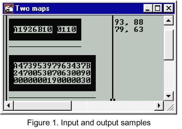
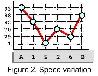
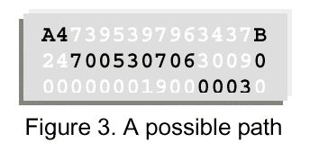
Figure 1 illustrates samples of program input and output (don't
worry about the fact that this is done in windows or that the 'X' characters
are solid blocks...) Figure 2 shows the vehicle speed variation for the
first map from figure 1. Figure 3 displays a possible path followed by
a vehicle with Vmin =79 and Vmax =63 on the second map from Figure 1.